Weekly Reports from Jordan
Choose Year: or Choose week
Weeks 2-6 -- Discovering the Archaeological Remains
Kent V. Bramlett, La Sierra University, author/editor and Jillian Logee, Calgary, AB, photographer
 |
 |
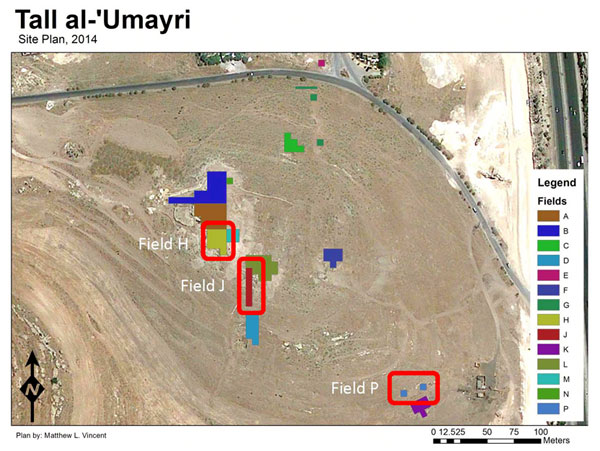
 The 2014 season of excavation at the Madaba Plains Project site of Tall al-`Umayri, Jordan was focused on three field locations (Fields H, J, and P) and one survey site (Site 84). Excavation at the southwestern corner of the acropolis, Field H, established the dates of some walls and made some progress in identifying the town’s southern perimeter wall in that location. Excavation in a straight-line series of squares down the southern slope, Field J, established that the southern side of the tell was fortified in the Iron I period (1200-1000 BC) with a packed-earth rampart, though we have not yet exposed the full length of the rampart or probable revetment and upper walls. Work on the southeastern shelf near the dolmen, Field P, was intended to ground-truth Ground-penetrating Radar (GPR) data from 2013. Excavation in the vicinity of two GPR anomalies has not revealed tomb features but further work is needed to complete the investigation. And nearly thirty agricultural installations were documented in survey work at Survey Site 84. These features represent utilization and increased exploitation of the landscape in the 8th-7th centuries BC, the Late Iron II Period.
Major archaeological periods
The periods represented at the site include all parts of the Bronze and Iron ages, with the exception of Middle Bronze I, evidently Late Bronze I, and some sections of the Iron ages. There was also a Hellenistic farmstead, Early Roman villa, and Byzantine farmstead.
Major strata
Stratum 22 (Chalcolithic Period) – 4500-3300 BC
Hiatus
Stratum 21 (Early Bronze Age IB) – 3200-3000 BC
Stratum 20 (Early Bronze Age II) – 3000-2600 BC
Stratum 19 (Early Bronze Age III) – 2600-2300 BC
Stratum 18 (Early Bronze Age IV) – 2300-2250 BC
Stratum 17 (Early Bronze Age IV) – 2250-2200 BC
Hiatus
Stratum 16 (Middle Bronze Age IIC) – 1650-1600 BC
Stratum 15 (Middle Bronze Age IIC) – 1600-1550 BC
Hiatus
Stratum 14 (Late Bronze Age II) – 1350-1230 BC
Stratum 13 (Late Bronze IIB/Early Iron I) – 1230-1200 BC
Stratum 12 (Late Bronze IIB/Early Iron I) – 1200-1150 BC
Stratum XX (Iron IA) – 1150-1100 BC
Stratum 11 (Iron IB) – 1100-1050 BC
Stratum 10 (Iron IB) – 1050-1000 BC
Stratum 9 (Iron IIA) – 1000-850 BC
Stratum 8 (Iron IIB) – 850-600 BC
Stratum 7 (Late Iron II/Persian – 600-550 BC
Stratum 6 (Late Iron II/Persian) – 550-500 BC
Stratum 5 (Persian) – 500-400 BC
Hiatus
Stratum 4 (Hellenistic) – 200-50 BC
Stratum 3 (Early Roman) – 50 BC - AD 135
Hiatus
Stratum 2 (Byzantine) – AD 350-650
Stratum 1 (Islamic) – AD 650-present
Major features of the site
The site incorporates nearly ten hectares (25 acres) at its base, and approximately 1.5 hectares (3.75 acres) on the acropolis. Located prominently along the major highway leading from the Queen Alia International Airport to Amman, Tall al-`Umayri is surrounded on the north, west and south by hills higher in elevation than itself, making defense a major challenge. This fact led inhabitants to take extra measures in construction of its defense systems over time. Showcase architecture includes the dolmen from the Early Bronze Age, the Middle Bronze Age IIC moat and rampart, a Late Bronze Age temple, Early Iron I domestic buildings, now four-five in number, a newly discovered pillared house, also from the Iron I period, a Late Iron II administrative center, and a Hellenistic farmstead.
Field-by-Field documentation
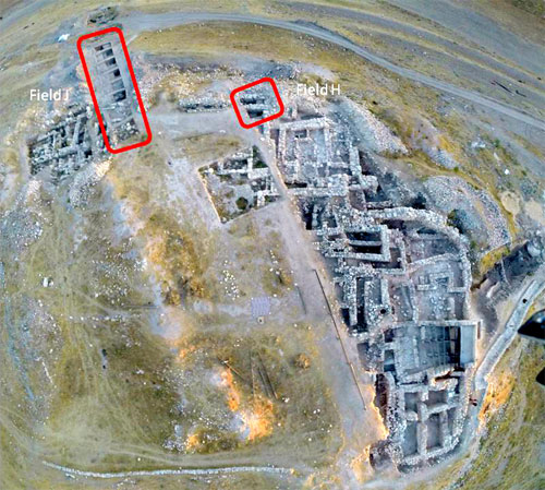
Field H: The Southwestern Acropolis
Monique D. Vincent, University of Chicago/La Sierra University, with the assistance of Mary Boyd, Langley, WA
This season in Field H the team returned to Square 7K02, located on the very southeastern-most edge of the field, on the brow of the tell, and 1.5 meters inside the property line of Dr. Raouf Abujaber who gave us permission to excavate on his land in 2014. This square was previously excavated in 1998, revealing the edge of a Byzantine structure, and a series of Late Iron II and Late Iron II/Persian period structures. The objective of this revisit to Square 7K02 was to explore the nature of the southernmost wall, Wall 2. During the 2012 season of excavation in Field H the top of the destruction layer of the Late Bronze/Early Iron Age settlement was discovered, confirming the southern extent of the settlement at the time. While the western settlement wall dating to this period has been excavated along the entire edge of the tell, where it turns and heads south remained unknown. Wall 2 is a strong candidate for this southern perimeter wall; however, only its later manifestations in the Late Iron II/Persian period are known at this point.
While our goal of determining the founding date of Wall 2 was not reached this season, we were able to confirm that the wall does predate the other walls in the square, which were founded in the Late Iron II/Persian period. The upper courses of Wall 2 date to the Late Iron II/Persian period, with characteristically very large stones for walls from this period. However, beneath the upper courses, more courses of smaller stones continued, for an incomplete height of nearly 2 meters by the end of season. The earliest earth layer sealing against it dates to the Late Iron II period, and the wall appears to continue further below.
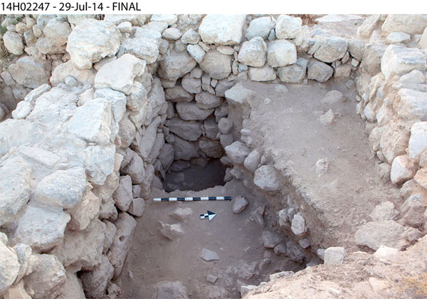
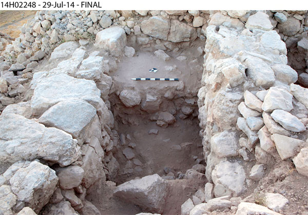 The walls in 7K02 define two distinct areas in the square, one north side of a large separating wall, and one on the south side. While the cobble surfaces in both areas were dated to varying periods in 1998, their removal this season confirmed that they both date to the Late Iron II/Persian period. Excavation south of the dividing wall revealed a slightly earlier plastered surface in a small room, on which was found a couple of reconstructable pottery vessels. Beneath this surface, however, was a tumble of large boulders and earth, perhaps used to raise the height of the room to the same level as the northern room, adjusting for the slope of the tell. The room does not have a clear access point, and may have been entered from above.
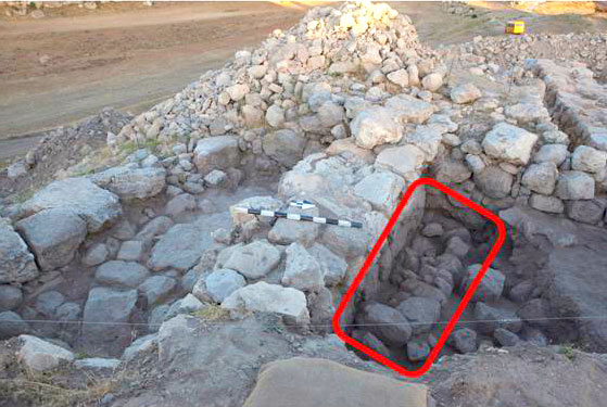 An earlier Late Iron II/Persian period phase of the northern area contained a large stone bench, measuring 2.3 meters in length along the central dividing wall, and 0.72 meters in width. Two other benches have been found in the Iron II remains of Field H, one nearby on the southern edge of the tell, and another in the center of a building north of this structure. Both of the other benches were found in contexts that could have been used for ritual purposes. This bench does not, however, appear to have been used for cultic purposes, as only sherds from a typical domestic assemblage were found nearby. At the same time, only part of this northern area was excavated, and whether this area is part of a room or outdoor space is not yet clear. Future excavation will help to determine the nature and use of this space.
Field J: The Southern Slope
Monique D. Vincent, University of Chicago/La Sierra University
This season we opened a new area of excavation, Field J, on the southern slope of Tall al-‘Umayri. Field J consists of seven consecutive squares that connect Field L in the north, on top of the tell, with Field D, down the southern slope. These two previously-excavated fields represent both ends of occupational history at the tell, with Hellenistic remains at the top of the tell, and Early Bronze Age remains at the bottom. The goal of opening Field J this season was to connect these fields stratigraphically and explore the nature of occupation and fortification on the southern slope.
 After studying several earth and rock tumble layers from the six squares excavated this summer, it is possible to reconstruct the story of the decay and abandonment of the later settlements at ‘Umayri. The earth layers contained pottery from all periods of settled occupation at the tell, from the Early Bronze Age to the Byzantine era, but with a majority of Hellenistic and Late Iron II/Persian period forms. These were mixed in among windblown soil, rock tumble, and mudbrick debris. The pattern of rock fall spoke eloquently of collapse, with large boulders toppling off of enormous walls at the top of the tell, probably from Late Iron II/Persian or Hellenistic structures, and tumbling to cover the top of the slope. Smaller boulders and cobbles rolled a bit farther downslope, while a heavy concentration of pebbles and pottery sherds washed down to the lower slopes. These layers of debris lacked any characteristic marks of destruction or burning, and probably represent simple erosion over the side of the tell from abandoned buildings on the top.
While some of the Bronze Age sherds found in the debris were probably in tertiary context, originating from the mudbricks, there were a significant number of Middle and Late Bronze Age sherds (including a couple of Mycenaean sherds) that were unworn and give a good indication of Bronze Age settlement nearby. A shelf halfway down the slope hints at the edge of a settlement on the tell, similar to how the Early Bronze Age settlement took advantage of even the lowest bedrock shelves on the tell. Unfortunately, excavation on this shelf did not reach below later wash during this season.
Four ephemeral field walls were found running horizontally along the slope, perhaps used during the Hellenistic periods to form small farming terraces. A very large stone structure, perhaps a retaining wall, stood at the base of the slope. The earliest layers sealing against the structure contained Hellenistic pottery, and the earth layer upon which it was built contained Late Iron II/Persian period pottery, providing a probable founding date between those two periods. No other significant architectural remains were found this season.
 The western slope of Tall al-‘Umayri is fortified with a series of retaining walls and earthen ramparts, dating primarily to the Late Bronze-Early Iron Age transitional period. One goal for excavating the southern slope was to determine if a similar fortification system existed to protect the southern slope, or if fortification was only necessary on the more vulnerable western slope. By the end of the season, a series of sharply sloping plaster, mudbrick, clay, and ashy earth layers was detected in the northernmost two squares of Field J, with pottery dating to the Iron I and the LB-Early Iron I periods. The nari, clay, and charcoal-filled earth layers, their 10°-20° slope, and the pottery provide evidence that this could be the remains of an earthen rampart system on the southern slope. As only small probes were excavated into these earth layers and no accompanying retaining walls were discovered, further confirmation will be sought in future seasons of excavation.
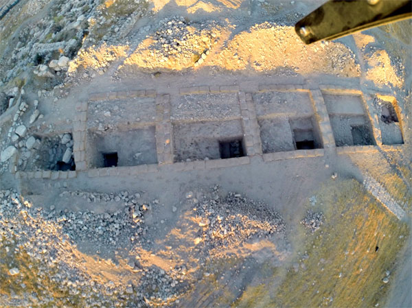
Field P: The Southeastern Shelf
Nikki Oakden, University of Calgary
The 2014 Season at Tall al-'Umayri saw the initial opening of Field P, adjacent to the Field K dolmen excavations of 1994 and later. This was done with the intention of further exploring the area and possibly expanding the previous excavations, as well as determining the presence of additional tombs or dolmens in the Field K area. Previous seasons' surveys and excavations discovered a megalithic dolmen dated to the Early Bronze Period and a Middle Bronze cave tomb, both containing multiple burials and in the case of the dolmen, some associated architectural features including a small retaining wall and a plaster surface.
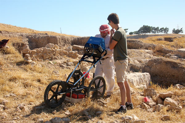
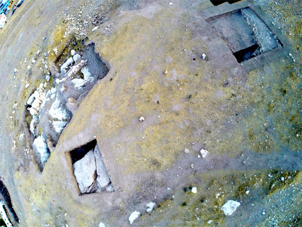 During the summer of 2013, a survey was performed using Ground Penetrating Radar (GPR) in the area surrounding the Field K dolmen. The results of this survey revealed several anomalies, or "hot spots," that appeared to indicate caves, depressions or openings in the bedrock beneath the earth surface. As mortuary features such as cave tombs, shaft tombs and the dolmen have been found in the surrounding valley near Tall al-'Umayri, it was decided in 2014 that these results should be explored through excavation. Two of these hot spots were chosen and one 6x6-meter square was opened to include each of them (Squares 4N80 and 4N93). These squares comprised the extent of Field P this season.
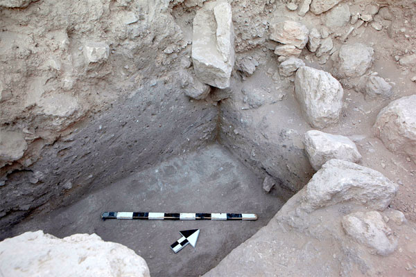
The first GPR hot spot, located several meters northwest of Field K, was marked as approximately 1 meter below ground level and was not fully identified this season due to a number of architectural installations discovered overtop of it. The excavations of Square 4N80 uncovered two small field walls running parallel in what appeared to be a semi-circular curve. Associated dates of these features are unclear due to the mixing of hillside tumble, but are likely post-Early Bronze and the difference in elevation between the two walls might suggest possible agricultural terracing. Below the easternmost terrace wall was an older wall, dating to the Early Bronze Age and directionally parallel to the natural curvature of the hillside as well as the wall feature in Field K. This feature appeared to have been subjected to some destruction or material recycling in antiquity, as what remained comprised only a single course of stones set atop a construction layer laid directly over the bedrock and covered by a mortar collapse. A large gap in the wall might be an entryway, or merely the result of further destruction. Bedrock is present in only the western half of the probe, thus continued efforts to determine the nature of the GPR hot spot in 4N80, as well as further exploration of the architectural features and their relation to Field K, may occur in later seasons.
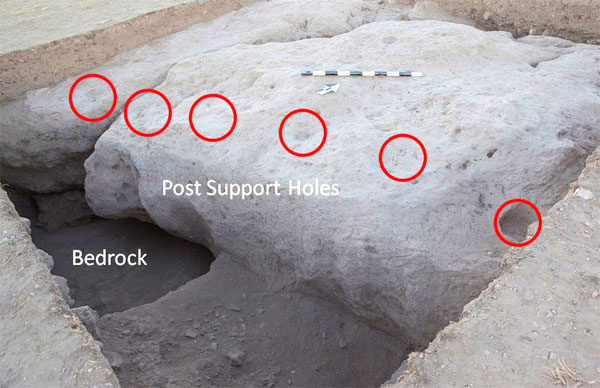 The GPR results for the area approximately 8 meters north of the Field K excavations showed another hot spot only 0.5 meters below the surface near the North balk of Square 4N93. This was quickly revealed as a naturally occurring fissure in the bedrock, likely from an earthquake. This event would probably have preceded the Early Bronze Age activity in this immediate area, as a plaster surface dated to the EB period had been laid directly into the crevice in the Northern end of the square. This surface and a series of four evenly spaced postholes may be related to a similar plaster surface laid in the South end of the square on the lower bedrock shelf, dating also to the Early Bronze Period. This second surface was accompanied by six evenly spaced postholes on the edge of the upper shelf, above a deep outcropping which had been filled in order to construct the plaster surface. The lower surface correlates closely in depth with a similar surface that had been previously found just south of 4N93, adjacent to the dolmen and visible in the Northern balks of Field K. These features and their corresponding Early Bronze Age dates may indicate the presence of one or more structures erected near the Field K dolmen, adding to the architectural features already associated with it.
While additional tombs were not discovered this season, a human mandible was found against the south balk of 4N93. Its association with the features in Field P or the dolmen in Field K is unknown, but it appears to come from a construction fill layer deposited on top of the plaster surface in 4N93. Further excavations in Field P may determine if it is the result of disturbance from tomb robbing in antiquity. There remain also additional GPR anomalies to explore in this area.
`Umayri Survey Site 84
David and Amanda Hopkins, Wesley Theological Seminary (retired)
The ancient workers on the hill-slope site of Umayri Survey Site 84 created a dense mélange of rock-cut features. Their activity has been surveyed often (1989,1992, 1994, and 2014). The prominent rectilinear structure 84:1 (9.8 meters X 9.8 meters) most likely managed intensive agricultural production. The remnants of this impressive activity lay partially exposed and partially hidden beneath a mantle of current agricultural activity dominated by thistle, thorny burnet and cotoneaster.
Excavators for the 2014 dig season concentrated on thorough documentation of the features that constitute Site 84. Documentation included newly identified rock-cut features, a curvilinear pressing surface and features that required significant clearing; a set of cup holes/postholes, pressing surface, and two large basins as well as one small basin.
Due to the discovery and clearing of these many features, excavators were unable to return to 84.15, a rock hewn cave with plaster on the walls and ceilings initially excavated in 2012. However, based on the evidence of chisel work and plaster, excavators continue to believe that it probably functioned as a cistern.
Plans for the 2014 season also included mapping features of the site on a GIS map in order better to understand the possible relationship of various features of the site to one another. Structure-from-Motion imaging and aerial photography facilitated detailed documentation of the site and its features.
Pressing installations of Site 84
The deeply eroded and degraded exposed bedrock landscape presented extraordinary difficulty for the process of identifying the presence and condition of rock-cut features. Even given this difficulty, most features seem to have a pressing surface, with all or some of these other attributes (associated cup holes, basin, and channel). This suggests that the facility for the initial stages of wine production occur within close proximity to each other. Absence of one of these attributes raises the level of uncertainty in the identification of the relationship between features.
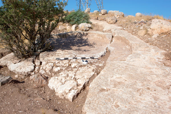 Some features include a pressing surface with one or more associated attributes (basin with channel, cup holes and additional basins). Feature 84:21c is a curvilinear pressing surface that is adjacent to a rock hewn ledge and only a few meters east of the farmstead itself (84:1). This feature is exemplary for its workmanship and preservation apart from one section that has been dislocated. Even though the above associations are visually absent, excavators believe that the surface was used for pressing grapes. Its uniformly dimpled floor and sloping circular walls would have made possible its function of pressing and containing the liquid. The absence of an associated basin may be the result of earthquake damage.
Basins of Site 84 not immediately associated to a pressing surface
The deterioration of the bedrock (as noted previously) did produce natural features that appeared to be possible basins. As excavators investigated these depressions, signs of human work (primarily chiseling) began to appear. Further clearing around these features showed that they were indeed basins and some of them had associated cup holes.
Mortars and Grinders
Mortars and Grinders were identified during the 1994 excavation of 84:1. Two additional features of this type were cleared during the 2014 season. These are approximately twice the size of those found within 84:1. They lack associated features.
Quarry Marks
 Countless quarry marks are a ubiquitous feature of the exposed bedrock of Site 84.
Water Management Devices
Site 84 offers three types of water management devices. These are reservoirs, cisterns, and wells, along with a well with a nearby trough. The incidence of modern capped wells still in use deepens appreciation for the richness of this site as a major agricultural resource both past and present. One reservoit is of impressive size. It measures 5 meters by 4.3 meters. Stone steps found in the NE corner led from the surface to the yet-to-be unearthed floor of the reservoir. The walls of the reservoir show chiseling. They and the steps show signs of dissolution where the topsoil fill rested against them. The NW wall has cracked along its face.
Wall Lines of Site 84
During the 1992 and 1994 season four wall lines were noted, of which the perimeter wall is still visible. One wall is wholly orthogonal and curvilinear. Another curves at a 110 degree angle from West to East and is sometimes two courses high with boulder-and-chink construction. The third is wholly orthogonal, consisting of one course. The final structure is a terrace wall that runs east-northeast with a 20 degree curve. It is incomplete and of varied construction types, including orthostatic chert slabs.
While there are many unexcavated features to be found at `Umayri Survey Site 84, a good sample has been identified and recorded. From this we can begin to see some associations among the features (e.g., pressing surfaces to basins and cup holes and basins with cup holes). This suggests that the facilities for the initial stages of wine production occur within close proximity to each other. Storage also fits within this category; however, none has yet been discovered aside from the probability of storage in 84:1.
One is also amazed by the sheer size of this agricultural installation. The facilities of Site 84 have yet to yield features associated with olive oil production (i.e., crushing facilities and separation vats).
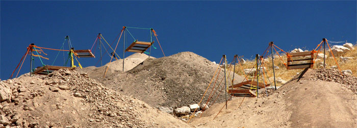
CyberArchaeology at `Umayri
 The 2014 season was intentionally arranged in order to allow testing of new technologies for the precise and accurate recording of tell features and discoveries. Of major significance were the use of an octicopter (UAV) capable of supporting GoPro cameras to produce 3D video and still photographs, a Steadicam for recording 3D videos, and Structure-from-Motion photographic technique in order to produce 3D stills of squares, features, large portions of the site. With these new technologies, provided in large part by a grant from the Versacare Foundation, the team was able to document everything from small objects to the entire tell site with fully manipulable images for a wide range of research applications.
 |
 |